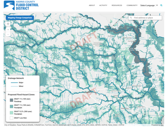
FEMAの洪水マップは多くの点で非常に重要です。まず第一に、住宅が高リスク洪水区域に含まれているかどうかを確認することができます。もし住宅が「100年洪水想定区域」または高リスクの「AE洪水区域」に位置している場合、金融機関は購入者に洪水保険の加入を義務付けます。2007年以来初めて、FEMAは長年の遅延を経て、グレーターヒューストン地域の一部における新しい洪水マップのドラフトを公開しました。これらのドラフトは、複数段階にわたる一般公開レビューのプロセスの始まりとなります。ハリス郡洪水対策局(Harris County Flood Control District)は、住所を入力することで現在の洪水区域マップと提案中の更新マップを比較できる使いやすいツールを作成しました。こちらからアクセス可能です: www.hcfcd.org/MAAPnext。住宅購入を検討されている方は、FEMAの洪水マップを確認することが重要です。今回提案中の新マップが公開されたことにより、近い将来変更が生じる可能性もありますので、上記リンクを確認し、今後どのような影響が考えられるか比較することをお勧めします。ご相談は案浦不動産までお気軽にお問い合わせください。
FEMA Flood maps are super important for many reasons. First, they tell you if a house is in a high risk flood zone or not. If a house is in the 100 year floodplain or the high risk AE floodplain, then a lender will REQUIRE a buyer to buy flood insurance. For the first time time since 2007, FEMA has released a draft of its NEW flood maps for portions of the Greater Houston area, following years of delays. These drafts begin a multi-stage public review process. The Harris County Flood Control District has created an easy-to-use tool where you can enter an address and compare current floodplain maps with the proposed updated. You can access it here: www.hcfcd.org/MAAPnext. For anyone thinking about buying a home, you should also check the FEMA flood map and now that the proposed new maps have been released, it is smart to check the link above and compare it to what may happen in the coming soon future. Call us at Annoura Realty Group for advice!